| |
 Located about 15 miles west of Winston-Salem, North Carolina, the Shallow Ford is, as its name implies, a shallow section of the Yadkin River which afforded a safe place for travelers to cross. In 1780 it was in Surry county. Today, its east entrance is in Forsyth county, its west entrance in Yadkin county. Located about 15 miles west of Winston-Salem, North Carolina, the Shallow Ford is, as its name implies, a shallow section of the Yadkin River which afforded a safe place for travelers to cross. In 1780 it was in Surry county. Today, its east entrance is in Forsyth county, its west entrance in Yadkin county.
In 1994, Victor M. Seiders, a geologist and a resident of Yadkin county, examined the geological nature of the Shallow Ford. According to Mr. Seiders, "a sand and gravel bar forms the Shallow Ford. Just above the ford, a belt of relatively hard rock appears to cross the river. Once this belt of hard rock is passed, the gradient of the river decreases. This causes a reduction in the velocity of the water and sediment is deposited on the bottom of the river to form the bar."
The origin of the Shallow Ford is obscured by time, and its age can only be guessed. When European settlers first came to the region, it was a game crossing and a natural fish trap, and was in use by the Indians.
Some of the dates important in the history of the Shallow Ford are:
- 1748. Six families (Carter, Bryant, Linville, Forbush, Davis, and Hughes) made up the Bryant Settlement near the Shallow Ford.
- 1749. Isaac Ferree obtained a license to operate a ferry near the Shallow Ford.
- 1753. Edward Hughes received a license to build a tavern at the Shallow Ford.
- 1753. The Moravians settled the Wachovia Tract east of the Yadkin, where they would build the towns of Bethabara, Bethania, and Salem.
- 1754. The Moravians cut a road from near Bethabara to the Shallow Ford.
- 1763. The cutting of a road from the Shallow Ford to Salisbury was ordered.
- 1770. The cutting of a road from the Shallow Ford to Mulberry Fields (North Wilkesboro) was ordered. The Mulberry Fields Road later connected to the Wilderness Road to Kentucky (cut in 1775), and became known as the "Daniel Boone Trail."
- 1772. The Moravians opened a road from Salem to the Shallow Ford.
- October 14, 1780. A large band of Tories crossed the Shallow Ford, then met and were defeated by Whig forces about a mile west of the Yadkin.
- February 7/8, 1781. Charles, Earl of Cornwallis' British Army crossed the Shallow Ford in pursuit of General Nathanael Greene's Army (which had crossed at the Trading Ford). The two forces were to meet at the Battle of Guilford Courthouse on March 15, 1781.
- April 11, 1865. General George Stoneman's Union Cavalry routed Yadkin County Home Guard guarding the Shallow Ford and crossed the Yadkin River. They had ransacked the town of Bethania, and went on to loot Huntsville and set fire to the Bitting "Red" Store there.
- 1912-1913. The Yadkinville highway bridge and the Clemmons-Mocksville highway bridge were built.
- 1913. The North Carolina DAR erected plaques near the Shallow Ford marking Daniel Boone's Trail.
- 1920. The West Bend bridge was built, ending the use of the Shallow Ford.
In Colonial times, the Shallow Ford was a focal point for travelers. While the Yadkin River could be crossed at other fords and ferries, heavier wagons could cross at only two places: the Trading Ford, near Salisbury (Rowan county), and the Shallow Ford (Surry county). Several roads converged on both sides of the river.
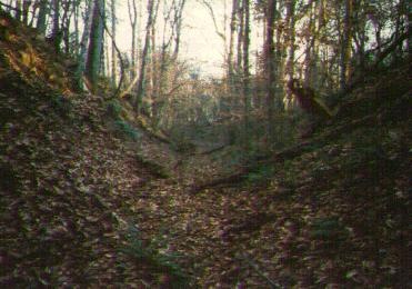 There has been a great deal of disagreement among historians as to the route of the Great Wagon Road from Philadelphia as it passed through North Carolina. The Jefferson-Frye map of 1755 showed it going to the town of "Unitas" [Bethabara] in the Wachau Tract, then crossing the Yadkin River to the west. The map was badly drawn and appeared to show the crossing to have been north of the Shallow Ford. Since the only documented road from Bethabara westward in 1755 crossed at the Shallow Ford, this author favors the theory that the Great Wagon Road crossed at the Shallow Ford in 1755. Subsequently, its route may have changed as roads and travellers' needs evolved, or it may have followed several alternate routes. At this time, documentation is inconclusive. Much of the Colonial road cut can still be seen on both sides of the river. There has been a great deal of disagreement among historians as to the route of the Great Wagon Road from Philadelphia as it passed through North Carolina. The Jefferson-Frye map of 1755 showed it going to the town of "Unitas" [Bethabara] in the Wachau Tract, then crossing the Yadkin River to the west. The map was badly drawn and appeared to show the crossing to have been north of the Shallow Ford. Since the only documented road from Bethabara westward in 1755 crossed at the Shallow Ford, this author favors the theory that the Great Wagon Road crossed at the Shallow Ford in 1755. Subsequently, its route may have changed as roads and travellers' needs evolved, or it may have followed several alternate routes. At this time, documentation is inconclusive. Much of the Colonial road cut can still be seen on both sides of the river.
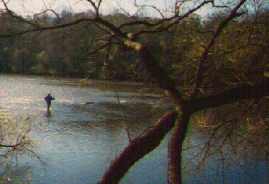
When the Yadkin was at normal or low levels, its depth at the Shallow Ford was about 18" or less. However, when the river flooded, it became too deep to be crossed safely. According to tradition, there was a rock, known as the ford rock, by which the level of the river could be gauged.
There was much activity in the Shallow Ford area throughout the Revolutionary War. The existence of a Muster Ground in the area is indicated by references to soldiers being mustered into and out of the service there, being paid there, and being ordered to report or march to the Shallow Ford. Small skirmishes abounded between local Colonists with opposing loyalties. During one of these in 1778, Umphrey Brumfield of Virginia was wounded.
There were two early settlements near the Shallow Ford. About a mile west of the Shallow Ford, Charles Hunt established the town of Huntsville in 1792. He laid out 111 half-acre lots and 66 foot wide streets. About five miles to the east, a settlement documented in the 1770s later became the town of Lewisville.
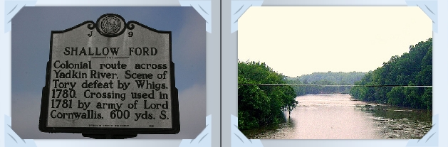
The Shallow Ford, a hub of travel for centuries, has drifted into obscurity since its use ended early in the 20th century. It is now bordered by wooded private property, hiding it from public view. A single historical highway marker denotes the role it once played.

ACKNOWLEDGMENTS: Victor M. Seiders, for his expertise on the geology of the Shallow Ford; Al Hudson and Kyle Stimson, for their expertise on Colonial roads and the Shallow Ford area.
© 1996-2011 Ann Brownlee. This page was created on December 1, 1996 by Ann Brownlee. Last revision August 2011.
|